Band of Holes Mystery Solved by Digital Archaeology in Peru
Article Content
For nearly a century, the Band of Holes—a sprawling, surreal formation of over 5,000 stone-lined pits snaking up a mountainside in Peru’s Pisco Valley—has served as a siren song for amateur theorists and internet mystery hunters. Often dismissively categorized as fodder for “ancient astronaut” narratives or bizarre, unexplained ritual sites, the formation known locally as Monte Sierpe (Serpent Mountain) has finally yielded to the rigorous, data-driven approach of modern digital archaeology. In a landmark study that underscores the transformative power of drone technology and microbotanical analysis, researchers from the University of Sydney have officially “cracked the code” of this long-standing cold case.
The Anatomy of an Andean Enigma
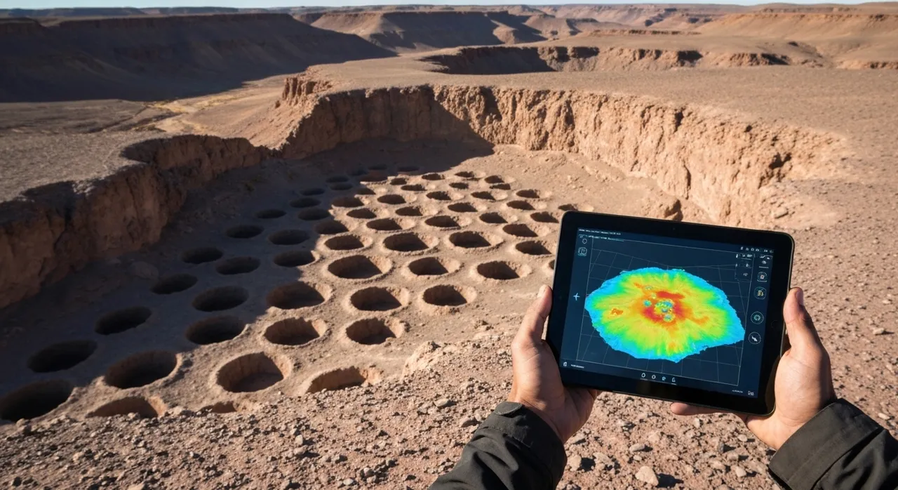
The Band of Holes is not merely a collection of indentations; it is a meticulously engineered landscape feature. Stretching approximately 1.5 kilometers across the stark, arid foothills of the Andes, the site consists of roughly 5,200 individual pits, each measuring between one and two meters in diameter and up to a meter in depth. When viewed from the air, the formation is breathtaking in its precision, winding sinuously up the 50-degree slope of the mountain.
Since the site was first brought to international prominence in 1933 via aerial photographs published in National Geographic, archaeologists have struggled to define its purpose. Previous hypotheses, lacking definitive evidence, were wide-ranging and often speculative:
- Defensive fortifications: Early explorers proposed they were pits for tactical warfare, though no evidence of weapons or conflict was ever recovered.
- Storage or Grain Silos: While functionally plausible in other Andean contexts, the lack of substantial debris or long-term storage evidence made this theory incomplete.
- Agricultural or Hydrological use: Theories suggested they captured fog or rainwater for irrigation, yet the hyper-arid nature of the Pisco Valley rendered these claims climatically improbable.
- Pseudo-archaeology: The vacuum left by legitimate scientific answers was rapidly filled by claims of ritualistic use or extraterrestrial origin, turning the site into an internet “fringe” staple.
Digital Archaeology: Cracking the Code
The breakthrough, led by Dr. Jacob Bongers and an international team of archaeologists, was made possible by the intersection of high-resolution digital mapping and traditional sediment analysis. The research, published in the journal Antiquity, highlights the shift from speculative interpretation to what is now being termed “Internet Archaeology”—the application of modern digital tools to solve legacy mysteries that have historically been misrepresented online.
Drone Mapping and Numerical Patterning
Using low-altitude, high-definition drone imagery, the team was able to create a precise digital elevation model of the entire site. This bird’s-eye perspective revealed something that ground-level explorers had missed for decades: the holes are not randomly placed, nor are they a continuous, uniform strip. They are organized into discrete blocks or sections, separated by distinct gaps that function as footpaths.
Upon closer numerical analysis, the researchers identified striking mathematical patterns. Some sections consist of multiple rows of exactly eight holes, while others alternate between counts of seven and eight. This level of repetition and organization suggests a deliberate, systemic function rather than an aesthetic or defensive one.
The Khipu Connection
Perhaps the most significant revelation from the drone data is the structural resemblance between the Band of Holes and the khipu—the highly sophisticated Incan system of knotted, colored strings used for record-keeping and accounting. A local khipu discovered in the Pisco Valley shares a nearly identical organizational structure of grouped numerical sequences. This finding posits that the Band of Holes functioned as a “landscape khipu,” a physical manifestation of an accounting database used by the Inca and their predecessors.
From Marketplace to Accounting Infrastructure
The research team’s analysis was not limited to topography. By conducting microbotanical analysis of the sediment trapped within the pits, archaeologists unearthed definitive traces of maize pollen, amaranth, chili peppers, and reeds commonly used for basketry. This provides a tangible narrative for how the site functioned:
- The Pre-Incan Era: The site likely originated as a vibrant, pre-Incan marketplace. Traders from the coastal regions and the Andean highlands would meet at this “chaupiyunga” (a transitional ecological zone) to barter their goods. They likely used woven baskets or fiber bundles, placing their commodities into the pits to keep them off the hot, dusty ground and to provide a clear, visible display of tradeable quantities.
- The Incan Era: Following the Inca conquest of the Chincha Kingdom in the 15th century, the site was repurposed. The Inca, renowned for their bureaucratic prowess and centralized control, likely recognized the utility of the existing grid. They transitioned the site from a free-market location into a state-managed accounting facility.
In this context, the pits were no longer just for storage; they were for verification. Each section of pits could represent a specific community or social group responsible for tribute payments. By visualizing the quantity of goods in the holes—taxation represented in a physical, quantifiable format—the Inca could effectively track, audit, and collect tributes across a massive, empire-scale distribution network.
Restoring Historical Context
The debunking of the myths surrounding the Band of Holes is a victory for the integrity of historical science. For decades, the site was defined by what it was not: it wasn’t an alien runway, and it wasn’t a site of mysterious, lost rituals. By applying digital methodology to legacy data, researchers have restored the site to its rightful place as an example of Indigenous ingenuity and complex administrative systems.
This discovery highlights a broader trend: the modern era of archaeology is defined by the tools that allow us to see what was previously invisible. Through drone imagery, spatial analysis, and microbotanical science, we can now discern the intentionality behind ancient landscapes. The Band of Holes stands as a testament to the fact that ancient societies were not “mysterious”—they were pragmatic, organized, and remarkably skilled at using the environment as a functional tool for economic and social development. The mystery of the “Band of Holes” is now a lesson in the sophistication of Andean civilizations, proving that the most fascinating stories are those written in the dirt by human hands, not the stars.
Written by
TempMail Ninja
Digital privacy and online security expert. Passionate about creating tools that protect users' identity on the internet.